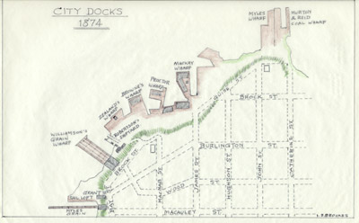
Plan of Hamilton Docks, 1874
Description
- Creator
- Ivan S. Brookes, Transcriber
- Item Type
- Maps
- Description
- Plan of Hamilton waterfront in 1874 to illustrate Ivan S. Brookes, Hamilton Harbor, 1826-1901. Redrawn from an original.
- Inscriptions
- "City Docks, 1874"
Signed "I. S. Brookes" - Date Of Event
- 1874
- Subject(s)
- Language of Item
- English
- Geographic Coverage
-
-
Ontario, Canada
Latitude: 43.274846329836 Longitude: -79.86412525177
-
- Copyright Statement
- Copyright status unknown. Responsibility for determining the copyright status and any use rests exclusively with the user.
- Contact
- Maritime History of the Great LakesEmail:walter@maritimehistoryofthegreatlakes.ca
Website:


