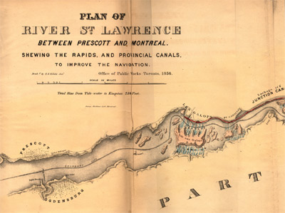
Plan of River St. Lawrence Between Prescott and Montreal Shewing the Rapids, and Provincial Canals, to Improve the Navigation.
Description
- Creator
- H. H. Killaly, Jr., Cartographer
- Item Types
- Maps
- Charts
- Description
- Nineteen foot long engraved map of the Saint Lawrence River between Prescott and Montreal produced for the Department of Public Works in 1854 as a supplement to the departmental report "Maps, Reports, Estimates, &c., Relative to Improvements of the Navigation of the River St. Lawrence; and a Proposed Canal Connecting the River St. Lawrence and Lake Champlain"
- Notes
- George Mathews, Montreal is credited as the lithographer
- Inscriptions
- "Plan of River St. Lawrence Between Prescott and Montreal Shewing the Rapids, and Provincial Canals, to Improve the Navigation."
"Draft'd by H. H. Killaly Junr"
"Office of Public Works Toronto, 1856"
"Total Rise from Tide-water to Kingston 234 Feet"
"George Matthews Lith. Montreal" - Publisher
- Canada. Department of Public Works
- Place of Publication
- Toronto, CW
- Date of Original
- 1854
- Subject(s)
- Collection
- Marine Museum of the Great Lakes at Kingston
- Language of Item
- English
- Geographic Coverage
-
-
Ontario, Canada
Latitude: 44.8698612138196 Longitude: -75.2296543121338
-
- Copyright Statement
- Copyright status unknown. Responsibility for determining the copyright status and any use rests exclusively with the user.
- Contact
- Maritime History of the Great LakesEmail:walter@maritimehistoryofthegreatlakes.ca
Website:


